 |
||
Home > TERATEC FORUM > Workshops > Workshop 1
Wednesday October 14, 2020 - Workshops
Workshop 01 - 09:00 to 10:30
Environment and satellite data: from abundance of applications to the surge of structured solutions
Chaired by Laurent Boisnard, Deputy Head of Earth Observation, CNES and
François Robida, BRGM
Satellite data for urban growth
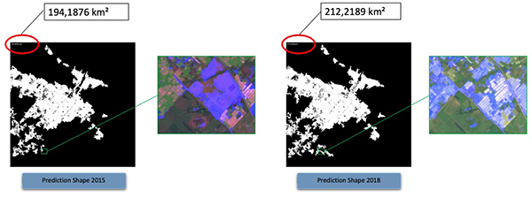 |
The 'Urban Space Series' product developed in partnership with ESA, the World Bank and QuantCube Technology is an AI platform for characterizing land, and specifically for detecting the urban area of the city, based on satellite images. Knowledge of urban development is a key element for the main players in the real estate market (real estate investors and large companies making long-term strategic investments) as well as for urban planners and public institutions.
For this, we have developed a methodology based on the analysis of Sentinel-2 images available with a spatial resolution of 10 m: the product 'Urban Space Series' allows to measure the evolution of the shape and size of the zones from satellite images. For the development and implementation of the 'Urban Space Series' solution, it was necessary to develop a robust algorithm capable of analyzing the large amount of data in satellite images. The algorithm is currently able to manage different topologies, densities and types of city construction. Indeed, cities have different infrastructures across continents, the fields can also be very different depending on the region and the season: all these different characteristics of cities must be learned in the training package.
Finally, we will share a major area of improvement in the years to come through our participation in the AI4GEO project, by integrating the analysis of 3D data allowing us to go to a more granular level on the characterization of cities.
This session will focus on how Sentinel-2 satellite data can measure changes in the shape and size of urban areas that are difficult to measure with traditional statistics.
 |
Biography : Alice Froidevaux - Lead Data Scientist at QuantCube Technology, Alice Froidevaux is in charge of managing the satellite image analysis team in charge of analyzing different data sources, from low resolution to estimate urban growth to high resolution to estimate the income of a specific industry or using multispectral images to predict agricultural production. |
 |
Biography : Thanh-Long Huynh - CEO of QuantCube Technology, in charge of all applications developed from the analysis of alternative data sources, including satellite data as well as textual data such as that from social networks or news. Thanh-Long has more than 20 years of research experience in the field of economics and finance. Graduated from ENSAE in statistics and the University of Chicago in financial mathematics. |
![]()
Register now and get your badge here
- TERATEC Forum is strictly reserved for professionals.
- Participation to exhibition, conferences and workshops is free (subject to seats available)
- On line registration is obligatory.
![]()
For any other information regarding the workshops, please contact :
Jean-Pascal JEGU
Tel : +33 (0)9 70 65 02 10
jean-pascal.jegu@teratec.fr
Campus TERATEC
2, rue de la Piquetterie
91680 BRUYERES-LE-CHATEL
France
![]()