 |
||
Home > TERATEC FORUM > Workshops > Workshop 4
Workshops
Wednesday June 23
Workshop 04 - 16:00 to 18:00
Satellite data dedicated to environment and climate: Digital twins ahead
Chaired by Laurent Boisnard, Sous-directeur adjoint, CNES and Christelle Loiselet, Expert engineer, BRGM
Spatial Climate Observatory: Thermocity, thermal imagery from space for metropolises
By Vincent Lonjou, Chargé d’affaire, CNES et Aurélie Michel, Ingénieure de recherche, ONERA
Co-authors :
Laure Roupioz, Ingénieure de recherche, ONERA
Xavier Briottet, Chargé de mission politique scientifique, ONERA
Marine Goret, Chargé d’études climat urbain, Météo-France
Maeva Sabre, Ingénieure de recherche, CSTB
Charles Pelé, Chef de la division « Conception des bâtiments performants », CSTB Samy Kraiem, Ingénieur climatologue, CSTB
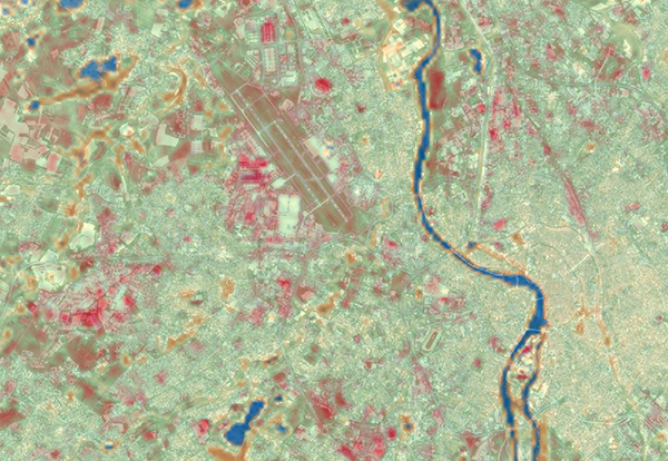 Toulouse pendant la vague de chaleur de 2003, en bleu les zones froides et en rouge les zones de surchauffe. © CNES |
Abstract: Satellite imagery is used to regularly derive the land surface temperature at a global scale. The THERMOCITY project aims to process the images for a specific kind of area: urban ones. Indeed, thermal infrared remote sensing provides relevant information for cities with two identified applications: study the surface urban heat island effect in summer and locate poorly insulated buildings with heat losses in winter.
First, optimal thermal images are retrieved over five case studies: Toulouse, Montpellier, Strasbourg, Paris and Marseille. Then, an emissivity and temperature separation algorithm is used, taking into account characteristics of the urban areas and providing a reliability index for all the final products.
One major problem in the satellite thermal imagery is the low spatial resolution. Downscaling methods are therefore applied to enhance the spatial resolution by combining with higher resolution images from the visible to the near infrared domain.
Furthermore, these thermal images can be associated with other spatial data (vegetation mask, type of building, local climate zones ...) and non-spatial data (socio-economic data, energy consumption...) to support the planning policy implemented across a metropole. The strategy for defining the best decision support indicators will be presented.
Finally, the last part of the project is about the modelling of the urban heat island effect. A comparison is made between models and satellite-based measurements in order to understand the benefits and limits of the two approaches.
 |
Biography: Vincent Lonjou est ingénieur au CNES depuis 2008. Il est actuellement chargé d’affaire au laboratoire d’observation de la Terre (Labo-OT). A ce titre, il est impliqué dans différents projets du Space Climate Observatory dont THERMOCITY pour lequel il officie en tant que chef de projet.
|
 |
Biography: Aurélie Michel est ingénieure de recherche à l'ONERA-DOTA à Toulouse depuis 2017 et s’occupe du traitement de données thermiques en milieux urbains afin de pouvoir mieux étudier l'effet d'îlot de chaleur urbain. A ce titre, elle est impliquée dans le projet THERMOCITY dont elle est la responsable côté ONERA. |
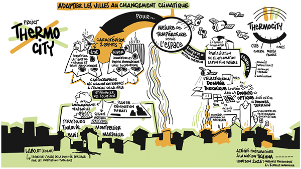 Le projet THERMOCITY en un coup d’œil - © CNES |
![]()
Register now and get your badge here
- TERATEC Forum is strictly reserved for professionals.
- Participation to exhibition, conferences and workshops is free (subject to seats available)
- On line registration is obligatory.
![]()