 |
||
Home > TERATEC FORUM > Workshops > Workshop 1
Wednesday October 14, 2020 - Workshops
Workshop 01 - 09:00 to 10:30
Environment and satellite data: from abundance of applications to the surge of structured solutions
Chaired by Laurent Boisnard, Deputy Head of Earth Observation, CNES and
François Robida, BRGM
Estimation of River Discharges from SWOT Observations using Data Assimilation and hydraulic Models
 |
|
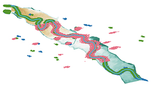
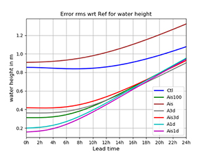
| Garonne 50 km reach between Tonneins and La Réole. Pixel Cloud SWOT-like observation for 3 SWOT swathes. | Global water height rmse with respect to OSSE reference for the ensemble mean of the assimilation experiments (Ctl : no assimilation, Ais : Assimilation of in-situ data lonely, Ais3d : assimilation of in-situ and 3-day SWOT data, Ais1d : assimilation of in-situ and 1-day SWOT data). |
River discharge estimation is at the core of environmental, economic, political and public security issues. Water community is putting a lot of efforts in making the most of the increasing volume of data coming from existing and upcoming satellite missions together with global ancillary databases in order to estimate river discharge. Hydrological rainfall-runoff models are widely used to work at large spatial (5-50 km) and temporal (day-month) scales. The SWOT (Surface and Ocean Topography) mission, based on SAR interferometry, will provide water surface elevations, slopes, and river width measurements for rivers wider than 100m, thus offering a great opportunity to work at river and reach scale and provide more detailed dynamics calculation with hydrodynamics models (200m-1km, 10-30mn time step).
The SWOT-River Discharge project, involving CERFACS and INRAE, aims at assimilating SWOT-like water elevation observations to correct model hydrological inputs and hydraulic parameters and thus improve discharge forecast with respectively ensemble-based and variational algorithms. It should be noted that, before SWOT mission launch, synthetic SWOT data are generated from simulated water elevation with 1D and 2D hydrodynamic models providing reference water elevation as input to SWOT-HR simulator.
HPC is a central node of the project first with respect to data management and second with respect to computational needs for ensemble generation.
Data management relates to the description of input data for hydrodynamics models, especially Digital Elevation Models, as well as for generation and use of assimilated data (water level SWOT-like data as well as auxiliary data). Indeed, the generation of a background topography and bathymetry requires access to SWOT observations time series and to global data bases from Copernicus program’s satellite and CNES data bases (such as THEIA) from altimetry, radar and optical imagery missions (ENVISAT, Landsat, SARAL-ALTIKA, Sentinel 1-2-3, …). Prior to SWOT launch, the merits of assimilating SWOT-like observations are shown in the context of Observing System Simulation Experiments. Synthetic data are generated with the SWOT-HR simulator that simulates the expected KaRIN measurements. SWOT observation data bases are built under different temporal and spatial density of the SWOT-like observing scenario over key study areas and periods, and then made available to the SWOT community. Additionally, incomplete SWOT data could be reconstructed using AI algorithms (Neural networks and Deep Learning) taking advantage of overlapping swathes zones.
For the data assimilation algorithm, an ensemble-based approach is favored at CERFACS as it is implicitly compatible with HPC and task parallelism. Uncertainties that relate to friction coefficients, bathymetry, topography and hydrological inputs are taken into account in the SMURF-MASCARET algorithm that provides a time-varying correction of model parameters and boundary conditions and consequently improved discharge forecasts. Task parallelism strategies with a Python-MPI as well as surrogate modeling approaches were investigated to limit the computational cost of ensemble-based assimilation and thus remain consistent with quasi real-time analysis. It was shown, over the Garonne river, that spatial and temporal densification of the observing network allows to limit the equifinality issue in the inverse problem and improve forecast capability for lead-time to up to 24-hour with reduced Root Mean Square Error computed with respect to the OSSE reference when dense SWOT data are used (Ais3d).
 |
Biography : Sophie Ricci received her engineer degree in Fluid Mechanics from ENSEEIHT in 2000 and defended her PhD on Ocean Data Assimilation in 2004 at CERFACS. After a post-doctorate at JPL-NASA, she joined CERFACS as permanent research staff in 2008. She is now in charge of water-related project in data assimilation and uncertainty quantification at CERFACS and defended her HDR in 2019. She has been a member of the SWOT Science Team since 2010. |
|---|
![]()
Register now and get your badge here
- TERATEC Forum is strictly reserved for professionals.
- Participation to exhibition, conferences and workshops is free (subject to seats available)
- On line registration is obligatory.
![]()